The day Florida has been dreading is finally here.
The state is hunkered down as Hurricane Irma regained strength to a Category 4 early Sunday.
Currently packing maximum sustained winds of 130 mph, the deadly storm is expected to hit the US mainland around 7 a.m. Its outer rain bands lashed the Florida Keys late Saturday, accompanied by winds of 74 mph -- hurricane force, the National Weather Service said. A 79 mph gust was recorded early Sunday as Irma drew closer.
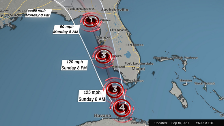
The storm is tearing itself away from Cuba's northern coast and is forecast to make landfall at Key West Sunday morning, before moving up Florida's west coast in the afternoon, the National Hurricane Center said.
Key West residents told CNN there was flooding on the city's streets early Sunday and KEYS Energy Services said all 29,000 of its customers -- from Key West to the Seven-Mile Bridge -- had lost power.
A resident of Big Pine Key said the water was rising.
"I'm not sure exactly how far above sea level I am, but I've never seen it flooding like this before at this house in seven years. It's about 8 inches above my concrete slab underneath my house now and it sure is making a racket. The wind is blowing for sure," Ira Kawzinsky told CNN. "It's not rain," he said. "Not here. It's surge. We're close enough to the ocean where any rain water would have run off."
Almost the entire state of Florida is under a hurricane warning affecting at least 36 million people, with concerns of devastating gales, heavy rain and life-threatening storm surge.
As Irma drew closer Saturday, officials warned the 6.5 million Floridians under mandatory evacuation orders that they were down to their last hours to make a decision.
"If you have been ordered to evacuate, you need to leave now. This is your last chance to make a good decision," said Florida Gov. Rick Scott at a news briefing Saturday evening.